Details
- Status
- Closed
- Publication date
- Deadline date
- Department
- Directorate-General for Defence Industry and Space
Description
The objective of EPICURE project (EGNOS Payment LIability Critical applications for Users in Road insurancE) was to assess the feasibility of a future EGNOS integrity service specifically designed for road insurance telematics applications in the 2025-2035 timeframe.
Contract Number: Call for Tenders No GROW/2019/OP/0003
Project Segment: Horizon 2020, EGNOS Mission and Services evolution
Duration: 18 months (July 2020 – December 2021)
Budget: €370 000
Project Partners: Thales Alenia Space (France), FDC (France), University Gustave Eiffel (France), know.space (Ireland)
Project Coordinator:
Hélène Delfour Cormier
helene.delfour@thalesaleniaspace.com
European Commission Project Manager:
Ignacio Alcantarilla
Ignacio.ALCANTARILLA-MEDINA@ec.europa.eu
EUSPA Project Officer:
Silvia Porfili
Silvia.PORFILI@euspa.europa.eu
Javier Ostolaza
Javier.Ostolaza@euspa.europa.eu
Background
EGNOS is the European SBAS and provides corrections and integrity information to GPS L1 C/A civilian signals for positioning and navigation applications over Europe. In particular, integrity information is provided as part of the EGNOS Safety of Life (SoL) service to meet the demands of safety-critical applications in the civil aviation sector (e.g. landing procedures) requiring enhanced and guaranteed performance to GPS standalone positioning solutions. The next generation of EGNOS, EGNOS V3, will augment GPS and Galileo constellations in the L1 and L5 bands and will extend the service area to the entire landmasses of EU member states.
The European Commission is defining the long-term evolutions of the EGNOS programme beyond EGNOS V3, including new services or uses of EGNOS. One potential evolution could lead to the provision of an EGNOS service tailored to liability and payment-critical application users and specifically to Pay As You Drive (PAYD) and Pay How You Drive (PHYD) applications.
Project objectives
The added value of EGNOS Open Service (OS) and EGNOS Data Access Service (EDAS) with respect to GPS is in the capability to provide enhanced accuracy and availability, independently from the proprietary/specific GNSS receivers’ technology.
Nowadays, there are products and solutions already available in the market benefiting from EGNOS OS and EDAS and providing:
- Position accuracy enhanced with respect to the GPS positioning solution;
- Increased reliability of the position through a specific level of confidence associated to the measured position, calculated by using the EGNOS delivered corrections and suitably customised for the road application, being a useful information of the relevant correctness especially in the case of potentially unfavourable environments.
- Time to first fix (TTFF) reduction, thanks to the retrieval of the GPS navigation message from EDAS, avoiding the need to wait for full reception of the GPS ephemerides by the GNSS receiver.
These solutions are currently limited, considering that there is no commitment offered by EGNOS service provider related to the use of EGNOS Safety Of Life (SOL) messages in other contexts than aviation. It is therefore an objective of EPICURE to define:
- An integrity concept customised to road insurance applications, in particular considering the various constrained environments applicable to these applications (e.g. urban environments).
- An EGNOS service which will efficiently support these applications, providing the necessary commitments on EGNOS messages used in such an integrity concept.
Results
The EPICURE project studied the basic principles and concepts for a future EGNOS integrity service, EPRIS (EGNOS Pseudo-Range Integrity Service), specifically to fit in the road insurance telematics applications. In this framework, the market’s stakeholders played an important role in the project, as they were consulted in key points of the project and were asked to provide inputs and feedback concerning various aspects.
They contributed in particular as follows through three interactions:
- The first interaction for gathering user needs and requirements concerning the GNSS positioning components and functionalities, through dedicated interviews
- The second interaction (still through dedicated interviews) for validating the service definition related to the designed integrity concept and for collecting inputs for the economic analyses and impact assessment;
- The third interaction through a webinar for having feedbacks on the elaborated roadmap, and possibly further recommendations and guidelines to be considered for the refinement of the roadmap.
From the first interaction, with the own values and ideas indicated by the respondents, a table of consolidated requirements was compiled for feeding the design of a possible new EGNOS integrity concept (and associated functionalities, features and services).
|
Performance parameters |
Targeted value |
|
Availability |
99.9 % |
|
Horizontal accuracy |
1m – 5m |
|
Vertical accuracy |
NA |
|
Time accuracy |
10ms - 1s |
|
Integrity |
None – 25m
|
|
Robustness to spoofing |
“Medium” |
|
Robustness to GNSS interferences |
“High” |
Table 1: Performances requirements (end-to-end solution) after stakeholder’s consultation
Starting from this table of requirements, a preliminary service definition was proposed (EPRIS: EGNOS Pseudo-Range Integrity Service), with performance targets recommended to be further consolidated.
A roadmap for EPRIS service introduction was also proposed with progressive service introduction in two steps:
- Step V1 (2025) : Single Frequency Single Constellation (GPS) service
- Step V2 (2029) : Dual Frequency Dual Constellation (GPS / Galileo) service
This EPRIS service fits into an overall user level integrity concept, with the following main characteristics :
- Adaptation to road environments, which are affected by harsh conditions (threats), where:
- Local errors are predominant (due to multipath more particularly)
- Direct path may be less numerous than indirect paths, and their distribution is not well known
- Environment is changing, with frequent signal outage, signal reflection
- Threats are either tackled locally by advanced GNSS antenna and receiver technologies or by the EPRIS service when adequate
- A Multi-sensor on-board unit (OBU) is proposed: GNSS is coupled with other sensor(s) within the on-board unit to cope with frequent GNSS signal blockage in terrestrial environment (at least Inertial Navigation System – INS)
As a summary, the following figure gives an overview of the functional architecture considered for the OBU, in line with the EPICURE proposed user-level integrity concept.
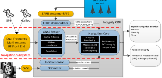
Figure 1 Overview of an integrity OBU model
An experimentation of this concept was performed in representative user conditions.
Some results show that there is still some work to be done to improve hybridization algorithm:
- with better measurement error modelling to improve integrity (e.g. taking into account time-correlated measurement errors)
- with addition of absolute sensors like magnetometers to improve navigation in tunnels.
However, it is considered that the obtained results already allow:
- To show the interests of EPRIS service to improve the accuracy of the user position and provide reliable integrity bounds in the pseudo-range domain
- To confirm that a user integrity concept based on the main principles and algorithms described in the project, with some improvements, would allow to comply with the main requirements expressed by stakeholders of insurance telematics applications
Finally, this work was also completed by an economic analysis which objective was to conduct a Cost-Benefit Break-Even Analysis of the proposed EPRIS service, focusing on the key conjoint decision-making stakeholders with respect to the adoption of EPRIS (i.e. GNSS Receiver Manufacturers (Rx manufacturers) and Telematics Service Providers (TSPs)). The key analytical objective of this analysis was to determine the minimum conditions to achieve commercially sustainable adoption by Rx manufacturers & TSPs for potential niche professional applications (i.e. the volume at which Total Costs = Total Benefits). Two break-even CBAs were conducted: one for Rx manufacturers and one for TSPs. The model was based on assumptions (high-impact and high-uncertainty assumptions adjusted as part of sensitivity analyses) and valuation estimation (of costs and benefits), which were informed by stakeholder consultations.
Under the base case scenario, the cost-benefit break-even analysis model determined that:
- For Rx manufacturers, the Break-Even Volume is 234,114 Rx units.
- For TSPs, the total aggregate OBU shipments (equal to Rx shipments, by assumption) is 234,114 over the 10 years of the lifecycle (i.e., 2025-2034), requiring a Break-Even Additional Revenue of €36.41 per OBU/year.
EPICURE final report is available here.
Impact
Recent European studies identified the road sector among the most promising for EGNOS where the generated benefits were extensively proven particularly for the so labelled “liability and payment-critical” applications. In such applications, where there is a charging or payment linked to a service contract which depends on the position information, relevant undetected non-availability or large errors can result into significant legal or economic consequences for the final users or the application provider. For example, road insurance telematics applications, such as pay-as-you-drive (PAYD) and pay-how-you-drive (PHYD) insurances today widely adopted, are based on the position information measured through a device installed on board of the vehicle (OBU). In presently operational insurance telematics solutions, the devices are largely based on the use of satellite navigation (GNSS) technologies integrated with additional sensors such as inertial sensors (gyroscopes and accelerometer) or odometer.
In EPICURE project, an integrity concept customised to road insurance applications was developed associated to a new EGNOS service definition for road users, which objective was to maximise the benefits for the users of these applications.
Furthermore, although EPICURE was focused on PAYD and PHYD applications, the possible links with other labelled “payment critical applications” PCA such as road user charging (RUC), and the relevance of present trends of the road market were also addressed. This has shown the interest of a possible wider extension to other applications, in order to stimulate GNSS RX manufacturers which are key decision makers.
Disclaimer: The project results represent the views of the consortium. They do not necessarily represent the views of the European Commission and they do not commit the Commission to implementing the results.