Details
- Status
- Closed
- Reference
- DEFIS/2020/OP/0006 – Aviation resilience to GNSS frequency jamming and cyber threats
- Publication date
- Deadline date
- Opening of tenders
Description
Duration: 24 months (Mars 2021 – Mars 2023)
Budget: EUR 1 500 000
Project Partners: GMV Aerospace and Defence S.A.U. as prime and sole contractor; GMV-NSL (Nottingham Scientific Ltd. - UK); NLR (Netherlands Aerospace Centre – The Netherlands); FGI (Finnish Geospatial Research Institute- Finland); ENAIRE (Spanish Air Navigation Service Provider); AXENTEK (GNSS receiver and algorithm development – Czech Republic).
Project Coordinator:
- Luis Javier Álvarez: ljalvarez@gmv.com
European Commission Project Officer:
- Eric Chatre: Eric.CHATRE@ec.europa.eu
European Commission Project Manager:
- Ignacio Fernández Hernández: Ignacio.FERNANDEZ-HERNANDEZ@ec.europa.eu
Technical Managers:
- Giovanni Vecchione: Giovanni.VECCHIONE@euspa.europa.eu
- Jose María Lorenzo: jm.lorenzo@rheagroup.com
Background:
The project AIRING (AviatIon ResilIeNce to GNSS Frequency jamming and cyber threats) addresses resilience of aviation operations to GNSS frequency jamming and spoofing threats. The project has assessed the threats on GNSS signals and resulting risks for civilian flights proposing mitigation, detection, and location techniques of RFI threats (focused on GPS L1/L5 and Galileo E1/E5a).
In the AIRING project several on-board and ground technologies with different Technology Readiness Levels (TRLs) as well as an operational concept to detect, mitigate and locate RFIs (jamming, spoofing) affecting GNSS in Aviation have been assessed with different methods in order to identify and recommend the implementation of a set of technological and operational safeguards that will contribute to increase GNSS resilience and thus achieve a medium or low level of operational risk by 2030, when a stronger dependency on GNSS to support the exclusive use of PBN based on GNSS is expected.
The final goal of the AIRING project was to define a Roadmap for the implementation of new technical and operational safeguards (in the short-, mid- and long-term) to improve the resilience of GNSS use in Aviation against RFI threats (including jamming and spoofing).
Building the AIRING Roadmap
To define the Roadmap the main activities performed in the AIRING project have been:
- To carry out an initial security risk assessment to estimate the level of operational risk expected in Aviation by 2030 (the reference timeframe), should no new technical or operational safeguards be put in place.
- To identify the candidate technologies that could be implemented in space, on-board an aircraft (or another aerial vehicle, e.g., drones), or on ground to act as technical safeguards against GNSS RFIs. Those technologies can be classified as:
- Detection: to enable an equipment (e.g., a GNSS receiver) to detect an RFI.
- Mitigation: to enable GNSS receivers to operate despite the presence of RFIs.
- Localization: to allow an equipment to help in locating the source of an RFI.
- Reversion: to provide non-GNSS PNT services (in case of loss of GNSS).
- To analyse the different technologies, and then to recommend the implementation of a sub-set of those technologies to help achieving the target level of operational risk.
- To carry out a quantitative assessment of the effectiveness of most of the selected on-board and ground technologies, through the execution of an extensive number of laboratory tests and live demonstrations, in which different Device Under Test (implementing one or several of those technologies) were subject to different RFI scenarios.
- To define an operational concept for RFIs management by the different stakeholders, which includes the identification of mitigation operational safeguards.
- To update the initial security risk assessment in order to estimate the remaining level of operational risk should those recommended technologies be implemented as technical safeguards, as well as the impact of operational mitigations on meeting the target level.
- To propose a timeline for the implementation at different stages (short-, mid-, and long-term) of the recommended set of technologies, and a Roadmap with the activities to facilitate the implementation of the proposed technical and operational safeguards.
To define the way forward towards the implementation of the recommended set of technologies (and the supporting operational concept) the European Operational Concept Validation Methodology has been used as reference (E-OCVM v3.0, Feb 2010).
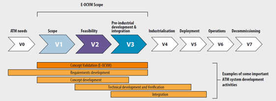
The goal of the E-OCVM validation activities is to complete V3 phase (pre-industrial development & integration).
Looking at the E-OCVM methodology, it can be concluded that, overall, the goal (and results) of the AIRING project corresponds to phase V2 (feasibility).
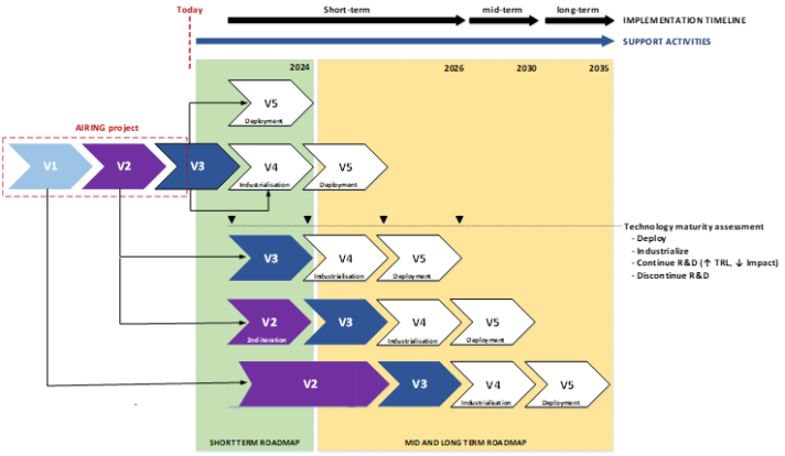
In AIRING the prototyped and validated technologies do not have the same TRL (Technology Readiness Level). They cover TRL ranges from TRL3 to TRL9, so they have different levels of maturity. Considering the level of maturity of each technology and other key criteria (impact, complexity, cost, and effectiveness), the timeline of implementation of the recommended set of technologies has been split into three periods: short-term, mid-term and long-term.
However, when talking about the Roadmap for implementation, we refer not only to the technologies but to the activities that should be carried out in the short-, mid- and long-term to support the implementation of the different technologies within their corresponding implementation timeline and to increase their maturity level (or reduce their complexity, impact, or cost).
The application of E-OCVM tailored to the AIRING context provides a view of these concepts: IMPLEMENTATION OF TECHNOLOGIES TIMELINE (as depicted on top of figure 2 and described further below) versus the definition of the ROADMAP FOR IMPLEMENTATION itself (as depicted in green/yellow colours in figure 2 and described further below):
Implementation of Technologies Timeline:
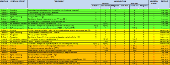
As a result of the full assessment, the following table summarizes the proposed timelines for both on-board and ground techniques altogether.
ROADMAP FOR IMPLEMENTATION
Given the complex nature of the technical elements (on-board, ground), operational actors (cockpit crew, ATCOs), and systems, project AIRING suggests splitting their integration and operational validation into two phases, the first phase to be performed within the short-term roadmap, and the second phase, if necessary, to be performed within the mid- and long-term roadmap.
Short-Term Roadmap
In this first phase, project AIRING proposes to carry out a partial integration and operational validation of some of the described elements (on-board and ground technologies), actors (cockpit crew, ATCOs), and systems (RFI monitoring networks, surveillance systems) taken together.
This short-term roadmap includes two types of activities:
- Those aimed at facilitating the implementation of recommended technologies in the short-term.
- Those aimed at increasing the maturity and/or reducing the impact or cost of the recommended technologies for implementation in the mid- and long-term.
Technologies to be implemented. The groups of elements, actors and systems proposed for this step are as follows:
- The integration and combined validation of the following detection and mitigations techniques proposed for the on-board GNSS receiver into an on-board GNSS receiver demonstrator, increasing their maturity and addressing for some of them requirements/conditions defined in MOPS:
- AGC with Running Digital Sum (RDS).
- Chi-square test on digital samples.
- Spectral and statistical detection – Simple Methods (Statistical Detection).
- Digital filtering – Simple Methods: Adaptive Notch Filter (ANF) & Pulse Blanking (PB)
- C/N0 monitoring (Received Signal Strength - RSS).
- Consistency checks (CCH) of measurements and PVT, and
- Multi-frequency Multi-constellation (MFMC) diversity.
The main goal of this task is to study the interaction between the mitigation techniques applied in the Front-End (and Pre-correlation) stage, with the detection techniques applied in the next stages of the processing chain, i.e., signal processing (correlation and post-correlation) and navigation.
- The integration and combined validation of an RFI monitoring network and a surveillance based RFI detection and localization system into a ground RFI detection demonstrator with the following techniques, increasing their maturity:
- RFI monitoring stations.
- Surveillance (ADS-B) based RFI detection and location.
- Prototype Application Programming Interface (API) to share the RFI related information.
The goal of this integration is twofold:
- To define how to reconcile (e.g., crosscheck) the RFI information coming from different sources and how to present this information to the involved actors. To achieve this goal Project AIRING proposes to prototype an RFI events simulator, an API, and an HMI to present the information to the operational staff. This demonstrator could be used to customize and validate the human performance (human factors) of the HMIs for the ATC, ATSEP and engineering personnel, leveraging their situational awareness of GNSS RFI events.
- To define and assess a reliable model to estimate the impact of a located RFI source on the surrounding airspace with enough assurance, so that consistent actions would be made by the ATCO in such area. The constrains regarding the trustworthiness of the information given by the system should also be assessed to avoid any misleading information that could lead to a safety issue or a misuse of the GNSS systems.
3. The preparation and integration of a real-time simulation environment to enable the operational validation of the interactions between cockpit crew and ATC controllers (with humans in the loop) to further develop the operational procedures and technical enablers required to manage different RFI scenarios.
4. To improve the laboratory environment to support the assessment of the on-board and ground integrated demonstrators: to be able to simulate more sophisticated attack, to increase automation of scenario generation, test execution, KPIs computation, to increase fidelity of simulation, to enable the combination of live data with simulated data, to enable the computation of additional KPIs, to integrate certified aeronautical receivers and to be ready to support tests in anechoic chambers and live environments.
5. To develop the operational concept to manage RFIs to take advantage of the on-board and ground technical and operational detection, location, and mitigation capabilities available today. It includes the definition of operational scenarios, use cases, roles and responsibilities, and safety requirements. It should cover Communications actions as well, Mitigation actions, Reversion to Normal Operations and Reporting of GNSS RFI to different involved stakeholders.
The aim of the activities described is to prepare specific material to support the industrialization and deployment of the technologies proposed for short-term implementation. This material would be the main output of the short-term roadmap, and would include:
- A refinement of the methodology proposed in the security risk assessment performed in AIRING.
- A refinement of the labelling scheme proposed by AIRING for the on-board GNSS receiver and for the ground RFI detection and localization equipment, that could be later incorporated into regulation, standardization, or technical material applicable to those systems.
- A set of proposals of specific additions or amendments (i.e., describing the text to be added or amended) of regulations and standards.
- A set of interoperability technical specifications for the ground RFI detection and localization systems and other enablers (e.g., an API to share information), addressing the operational and performance requirements of the proposed solutions, for instance, to address the high-level standards applicable to the systems that work into the ATM network (e.g., SWAL), and the integrity and reliability of the data to be provided by the systems.
- A detailed Operational Concept and recommended operational procedures, that could be tailored by the different ANSPs to their operational needs.
- Training and awareness material that could be provided to stakeholders to help them understand the characteristics, likelihood, and impact of RFIs affecting GNSS, as well as the technical and operational solutions available and how to make the best use of them.
- To make some Customer Furnished Items (CFIs) available to stakeholders, such as:
- A prototype of the API (including the source or object code and use documentation).
- A data set with reference GNSS and RFI adverse scenarios (which, for instance, could be used to apply the labelling scheme and methodology described above).
- The use of the laboratory set-up as a service for other projects.
To increase the maturity and/or reduce the impact or cost of a sub-set of technologies recommended for implementation in the mid- and long-term. The groups of elements proposed for this step are as follows:
- Technologies assessed in the AIRING project:
- Controlled Radiation Pattern Antenna (CRPA).
- Dual Polarization Antenna (DPA).
- Correlation Peak Monitoring (CPM).
- Galileo Open Service Navigation Message Authentication (OSNMA).
- Other technologies that were not assessed in the AIRING project:
- Multi-Antenna – Using currently deployed dual antenna architecture.
- Spectral and statistical detection + Digital filtering – Complex Methods.
Mid and Long-Term Roadmap
In the mid- and long-term roadmap, the Project AIRING proposes activities to:
- Widen the scope of the EU Space programmes to improve GNSS resilience in Aviation by addressing:
- Impact on current (e.g., EGNOS V2, Galileo HAS), short-term (Galileo OSNMA) or mid- and long-term E-GNSS services (e.g., EGNOS V3, ARAIM, SBAS L5 NMA, EGNOS evolution, G2G).
- Other applications of the GNSS receiver beyond positioning (e.g., generate a time signal to feed other on-board equipment or CNS systems on ground; be part of a GBAS station, RIMS or GSS).
- Use of GNSS in aviation beyond ATM, in particular the specific conditions (e.g., on-board equipment, operational context, missions, stakeholders) of U-Space.
- Increase the maturity and/or reduce the impact or cost of other recommended technologies for implementation in the mid- and long-term:
- On-board technologies: Synthetic Antenna Array, Spread Code Authentication (SCA), Other NMA services (e.g., on SBAS L5), Consistency checks with INS and Consistency check with other navigation and positioning technologies.
- On-ground technologies:
- Spoofing detection by comparison with non-GNSS surveillance means (e.g., WAM/MLAT).
- Spoofing detection and localization by comparison with non-GNSS multilateration based on the processing of the RF surveillance signals (e.g., ADS-B).
- Use of drones equipped with RFI detection and localization technologies (e.g., those able to measure the Angle of Arrival (AoA) of the RFI signals) to enhance ANSPs capabilities.
- Other technologies:
- Space-based detection and localization techniques.
- HAPS (High Altitude Platform Station, a.k.a. High-Altitude Pseudo Satellite) based RFI detection and localization system.
- A-PNT systems, both GNSS-based (e.g., LEO PNT) and non-GNSS.
- Increase the level of integration and fidelity of the researched on-board and ground technologies.
Finally, the mid- and long-term roadmap may also include activities to support the integration and operational validation of the on-board and ground demonstrators proposed before, to make the operational validation closer to resemble the final operational conditions (e.g., on-board and ground demonstrators running in real-time on representative HW platforms).
Expected Impact
The AIRING project has assessed the threats on GNSS signals and resulting risks for civilian flights proposing mitigation, detection, and location techniques of RFI threats (focused on GPS L1/L5 and Galileo E1/E5a), which occurrences are slowly increasing.
The final result of the AIRING project has been a Roadmap for the implementation of new technical and operational safeguards (in the short-, mid- and long-term) to improve the resilience of GNSS use in Aviation against RFI threats (including jamming and spoofing). This Roadmap was based on a throughout analysis of the different techniques and their application in different Aviation operational scenarios.
It is expected that the results of the project would encourage some actions on the interested Aviation stakeholders, considering some of the outputs of the project as inputs to new projects, to feed existing activities, or to define new ones, since it has been proven that the objectives of the project were achievable and that the outputs are valuable for the Aviation community, considering the wide range of topics covered by the project.
As a first and immediate action, it is expected to launch a project to demonstrate the feasibility of implementing the most promising and mature On-board Resilience Techniques against GNSS Frequency Jamming and Spoofing in a GNSS Receiver Prototype or Demonstrator (hardware and/or software).
It is also expected that some of the outputs could feed an eventual Concept of Operations (CONOPS) if agreed among relevant stakeholders.
Disclaimer
The project results represent the views of the consortium. They do not necessarily represent the views of the European Commission and they do not commit the European Commission to implementing the results.