
Copernicus provides accurate, timely, and easily accessible information to users around the world, improving the operations of emergency management services, deepening our understanding of climate change, helping us better manage natural resources and conserve biodiversity, and much more.
Using a series of dedicated satellites, known as the Copernicus Sentinel missions, it provides high-quality data and images for informed decision-making. Among these, Sentinel-2 stands out for its multi-spectral optical capabilities, providing detailed views of land, vegetation, water quality, and improving our ability to respond effectively to environmental challenges. In this week’s Observer, we look at 7 times the Copernicus Sentinel-2 satellite mission gave us stunning images of our planet.
Launched in 2015 and 2017, the two Sentinel-2 satellites have dramatically improved our Earth Observation (EO) capabilities. With a swath width of 290 km and the powerful Multi-Spectral Instrument (MSI) on board each satellite, Sentinel-2 covers the Earth's surface with remarkable accuracy and a revisit period of five days with both satellites working in tandem. The MSI captures images in 13 spectral bands, including four bands at 10-metre resolution, six bands at 20-metre resolution, and three bands at 60-metre resolution. This wide range of spectral bands, from the visible and near-infrared to shortwave infrared, enables highly detailed land monitoring.
By combining the vast amounts of data from satellites such as Sentinel-2A and Sentinel-2B with data from in situ monitoring networks, such as ground based weather stations, ocean buoys, and air quality monitoring networks, the Copernicus Services deliver products to users all over the world. In a recent edition of the Observer, we celebrated the anniversary of Sentinel-2A launch by looking in detail at how Sentinel-2 has made important contributions in land monitoring, ocean monitoring, climate change monitoring, and emergency management since its launch in 2015. Todat, we shift our focus to the aesthetic side of Copernicus Sentinel-2 imagery and its remarkable optical capabilities by looking at seven stunning images of our planet produced with Sentinel-2 data.
1) Wildfires in the Alentejo region of Portugal
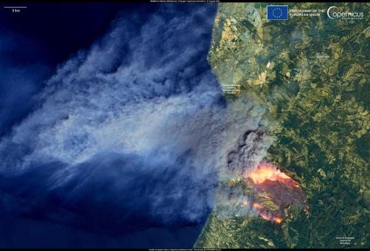
In August 2023, Portugal suffered a series of severe wildfires, primarily affecting the Odemira municipality in the Alentejo region and spreading toward the Algarve, a popular tourist destination. The above image, captured by one of the Copernicus Sentinel-2 satellites on 7 August 2023, shows glowing orange and red fire fronts, with a massive smoke plume extending from the fire toward the northwest and over the Atlantic Ocean. This image was produced using Sentinel-2's short-wave infrared (SWIR) bands, B11 and B12. Band B11 is sensitive to thermal radiation from hotspots, such as fires. The SWIR wavelengths in this band can penetrate smoke and thin clouds, allowing information to be retrieved even in the presence of smoke. Band B12, similar to Band B11 but with a longer wavelength, provides improved penetration through smoke and dust. This band is particularly useful for detecting very high temperatures, such as those generated by intense fires. It is also effective in distinguishing extremely hot surfaces from their surroundings. The combined use of bands B11 and B12 enables accurate fire mapping and early detection, which is critical for effective emergency management and response.
2) Widespread flooding in Greece caused by Storm Elias
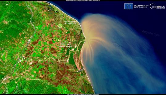
In October 2023, the Pinios River in Greece was heavily impacted by widespread flooding caused by Storm Elias. The above image was acquired by the Copernicus Sentinel-2 satellite after the storm and vividly displays the resulting sediment plume, with hues of tan and light brown, extending into the deep blue Aegean Sea. Images such as this Copernicus Sentinel-2 acquisition, illustrate our ability to monitor more than just the interior of continents. It is also an essential tool for monitoring coastal areas, obtaining information on changes in coastal boundaries due to climate change, monitoring coastal erosion, coral reefs or the quality of waters close to the mainland, among many other applications.
3) Volcanic Eruption on the Reykjanes Peninsula in Iceland
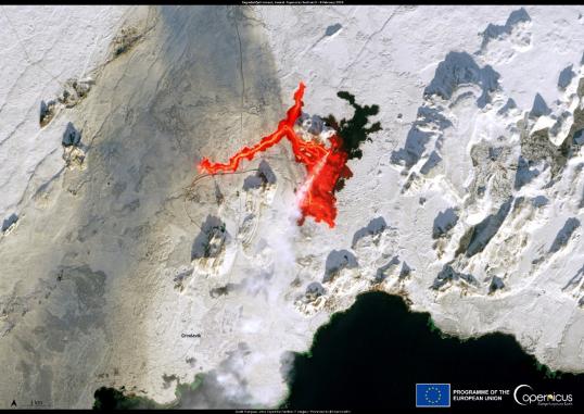
On 8 February 2024, the Fagradalsfjall volcano in Iceland erupted for the third time since December 2023. The above image, acquired by a Copernicus Sentinel-2 satellite on 8 February 2024, dramatically shows the vivid red lava flows carving through the snowy landscape. This visualisation is another prime example of how important the SWIR bands are for visualising areas of higher temperature, such as where lava from the volcano is spreading—a key metric, especially when lava approaches urban areas, as is the case of this image where it is seen near the town of Grindavík.
Discover the remaining 4 in the Copernicus Observer
The Sentinel-2 Satellite Mission Continues with the Launch of Sentinel-2C
The launch of the Copernicus Sentinel-2C satellite, scheduled for early September 2024, will reinforce the world’s most advanced Earth Observation infrastructure by ensuring system redundancy, which is crucial in case one of the existing satellites becomes unavailable. Sentinel-2C will eventually replace the older Sentinel-2A unit as it approaches the end of its functional lifespan, thereby ensuring the continuity of the Sentinel-2 mission and ensuring an uninterrupted supply of high-quality data. This data is invaluable for Copernicus Services products and information, but also for “downstream” service providers across a range of applications, including monitoring climate change impacts such as wildfires, floods, and droughts, as well as contributing to improved natural resource management and more effective responses to environmental challenges.
Details
- Publication date
- 11 July 2024
- Department
- Directorate-General for Defence Industry and Space